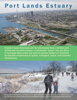
PROJECT STATEMENT: The Port Lands Estuary proposal heralds a new relationship between the urban and the natural. Developed by an integrated team of designers, engineers, and ecologists, the plan introduces urban development, native ecologies, and public infrastructure to 280 acres of Toronto's post-industrial Port Lands. This planning framework for a vibrant new mixed-use riverfront and lakefront neighborhood is developed through a landscape-based approach that unifies the goals of ecological restoration and urban design with potentially transformative effects.
PROJECT NARRATIVE: Major world cities such as Toronto are in transition, needing to re-integrate strategically important post-industrial landscapes while reframing their interactions with the natural environment. The Port Lands Estuary proposal is unique among these efforts by virtue of its size, scope, and complexity. In this proposal, the engine of transformative urbanism is a radical repositioning of natural systems and attendant landscapes, transportation networks, and urban environments. The imperative of sustainable flood control leads to relocating the river mouth and a renewed recognition of the functional and experiential benefits of river ecology makes it the symbolic and literal center around which new neighborhoods can be constructed.
This master plan unites innovative design approaches from landscape architecture and urban design with innovative scientific approaches to natural reclamation at the scale of the city and the region. Within this plan to recycle 280 acres of Toronto's waterfront, the Port Lands Estuary proposal fuses the client's major programmatic initiatives into a single framework that will simultaneously make the site more natural (with
the potential for new site ecologies based on the size and complexity of the river mouth landscape) and more
urban (with the development of a green mixed-use district and its integration into an evolving network of infrastructure
and re-connection). Both the urban and the natural elements of the landscape introduce complex new systems to the
site that will evolve over the course of many years, creating interim conditions, each interesting in its
own right, which give form, focus, and character to the development of the neighborhood.
Project Goals: A New Neighborhood, a New Relationship with the River
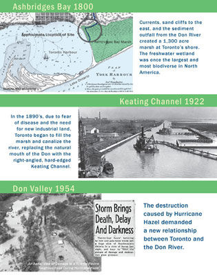
The site is located on a former wetland (the largest on the Great Lakes) created by the Lower Don River as
it emptied into Lake Ontario but filled in the early 20th century. Existing conditions include an abundance
of impermeable surface, a river diverted into a canal, rail lines and an elevated highway that create a barrier
between the Port Lands and the remainder of the city. Devoid of natural features, public infrastructure, and
neighborhood amenities, the site is fundamentally incapable of supporting new urban growth. Building on initiatives
that were being undertaken elsewhere along the waterfront, the client, a public redevelopment agency formed by
the federal, provincial, and municipal governments, sought to transform the site into new mixed-use neighborhoods
that would meet strategic development goals while demonstrating a new attitude toward the river and the harbor through
the creation of a naturalized mouth to the currently channelized and abused Don River.
Our plan results from the winning solution of an intensive eight-week design competition with an
international team of designers, engineers, and ecologists, headed by the landscape architects. Our Port Lands Estuary
proposal applies an evolutionary approach rooted in ecological principles to the emergence of new neighborhoods.
The plan draws extensively on the varied site histories, ecologies, surrounding context, and potentials for future
use. Employing an integrated landscape-based methodology of city building developed in close collaboration with
a diverse client group, the plan reaches across disciplinary lines to link the client's goals of introducing urban
development, native ecologies, and public infrastructure to an obsolescent industrial site in order to transform
it into a vibrant new sustainable community for Toronto.
Understanding the Site, Transforming the Site: The Intersection of Design and Science
Because of decades of wetland filling, the original mouth of the Don River is no longer adjacent to Lake
Ontario. The current mouth of the Don River is an artificial remnant of an era of city building in which a land filled
industrial port was considered the highest priority, although the Depression and changes in marine technology
frustrated that goal. In addition, major transportation corridors had created a vacuum between the struggling
industrial port and historic and newly emerging city neighborhoods on the other side of major rail and highway
barriers. Reflecting a vastly different set of values, the competition sought an integrated solution that would
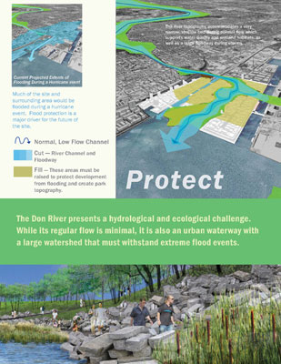
provide a new naturalized mouth to the river serving the environmental needs of the river and the lake, remediate
contaminated sites, provide flood control for a large area of downtown Toronto, and forge a compelling new
identity for a Lower Don Lands neighborhood. Given the unprecedented opportunity to transform the city's relationship
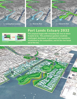
to the river, the planning team approached the commission with two initial questions: “Where does the mouth
of the Don River want to be?” and “What form can the river give to the new neighborhoods it traverses?”
The overall framework for the new neighborhood is supported by the detailed information provided and
the intense analysis undertaken by the landscape architect team leaders, urban designers, architects, river hydrologists,
regional ecologists, microecologists, climate engineers, bridge engineers, traffic and transportation engineers,
and civil and marine engineers. The team used these combined resources to explore issues of infrastructure,
recreated nature, neighborhood identity, and urban environments in a series of rapid and integrated iterations rooted
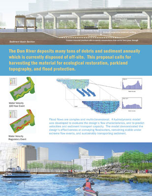
in the scientific realities of the project's environmental ambitions and constraints. The analysis of hydrology
and flood control was used to understand how the landscape needed to function in both flooded and non-flooded conditions.
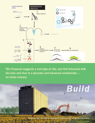
An examination of how to employ the river's sediment deposits inspired plans to improve the river's function
by dredging, while also providing the project with inexpensive materials for establishing a new topography on the flat
and featureless man-made port landscape. Ecological analysis was paired with an understanding of microclimate
as a means of creating new habitat for plants and animals alongside new recreational opportunities that would
support a new urban life on the site.
Repositioning the River
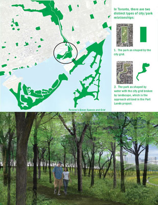
A significant part of the urban analysis included understanding how the origins of Toronto's two dominant park typologies
- rectilinear parks shaped by the urban grid and irregular parks shaped by the topography of the extensive ravines
- might be used as precedents for the kind of urban/park relationship that was going to be established in the
Lower Don Lands neighborhood. Instead of creating naturalized banks along the straight course of the existing channel
connecting the Don River with the lake, as was originally suggested in the project brief, the Port Lands Estuary
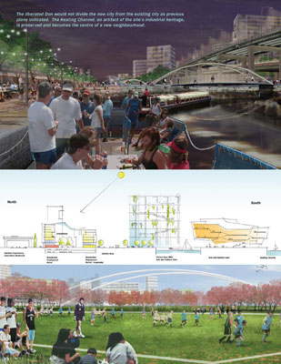
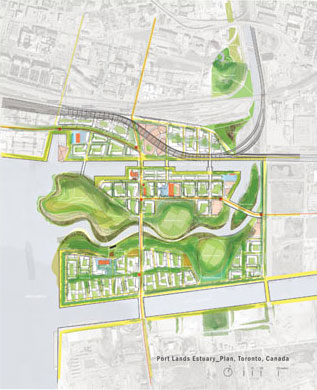
proposal keeps the Keating Channel as an urban artifact and neighborhood amenity and creates a new mouth for
the river that flows logically from the upstream source, bypassing the abrupt right turn created by the channel.
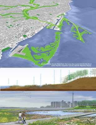
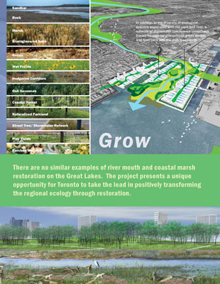
A large new meandering riverfront park becomes the centerpiece of a new mixed-use neighborhood.
The team's relocation of the mouth of the "new" Don River estuary makes it highly
visible from other points around Toronto Harbor, reasserting the river's lost presence in the city and allowing it
to become a new symbol of the revitalization of the Lower Don Lands as a whole. The shifting of the river's
mouth also creates a highly desired setting for new urban development, reinforced by stronger links to the
existing and emerging new neighborhoods north of the tracks, as well as associated development elsewhere
along the Don. In this way, naturalizing the mouth of the river not only creates a richer site ecology, but also has powerful positive
impacts on the urban form of the Lower Don Lands, adding kilometers of park front and waterfront property, as
well as a sustainable “urban estuary” of great richness and complexity on multiple and mutually
reinforcing levels: spatial, ecological, functional, economic, and social.
Transforming the Site and the City
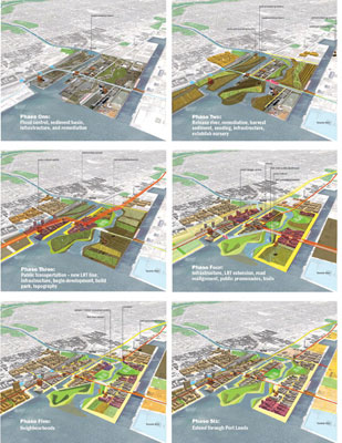
Within this unique setting, the Port Lands Estuary proposal envisions the sequential development of a series of
distinct neighborhoods with a range of block patterns and building typologies on sites formed by the river
and the harbor. The team's goal was to enhance the qualities of exciting new kinds of places to live, work, shop,
recreate, and visit in Toronto, where city, parkland, estuary, the preservation of key historic artifacts
including historic silos, and an active recreational harbor all contribute to unique neighborhood identities,
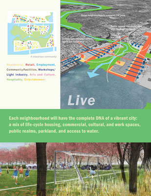
each with the complete DNA of a vibrant city: a mix of life-cycle housing, commercial, cultural, and work
spaces, public realms, parkland, and access to water.
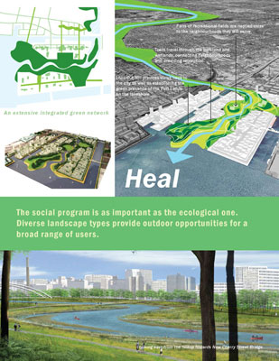
In the vision for the park at the heart of this urban estuary, the social program was recognized
as important as the ecological one. As proposed, the landscape will teem with activity: active sports in
the four regulation-size fields, informal pickup games, kite-flying on the mound overlooking the Inner Harbor,
jogging and in-line skating on the trails, and bird-watching, strolling, and contemplation along the more secluded
paths. Within each neighborhood, the proposal envisions multiple opportunities for social interaction on broad
tree-lined sidewalks, in cafés, in the squares, and during games on the play fields that are tucked
in throughout the park. Rock climbing, markets, festivals, and restaurants will energize the impressive colonnade
under an elevated expressway that had previously cut the site off from the city, providing a memorable backdrop
for a new expression of urban life.
The plan is broad in its vision as a framework with the capacity to evolve, but also very specific
in its attention to the quality of the public realm. Individual neighborhoods are discussed in detail with
particular attention paid to views within the district and beyond, the provision of social infrastructure -
schools, daycare, community centers, local shopping and amenities, and the way that the new development
will interact with the site's industrial history. The plan is anchored by a holistically conceived three-dimensional
public realm in which buildings and open spaces are partners of equal importance in safeguarding the quality
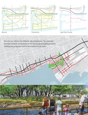
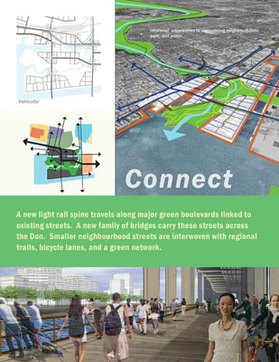
of the environment by ensuring adequate solar exposure and wind protection, and circulation networks that favor
pedestrians and cyclists. By mandating built-form that meets stringent environmental standards, the plan will
ensure a green civic-minded architecture through solicitations to developers in keeping with the broad environmental
and sustainability goals adopted by the client and the City.
An Urban Estuary
The Port Lands Estuary proposal describes a new type of neighborhood for Toronto, one that is designed to
interact with the river and the lake in a dynamic and balanced relationship – an urban estuary. Integrating
the contributions of design, engineering, environmental specialists and economic advisors, the proposal stakes
out an integrated approach to reclaiming 280 acres of abandoned port lands in the heart of the city. An extensive
and intensive permitting process is now taking place and construction of the new river and associated parkland-ecologies
is anticipated in 2010.
 |
|
PROJECT RESOURCES |
|
|
Team Leader and Landscape Architect:
Michael Van Valkenburgh Associates, Inc., Landscape Architects
New York, NY
MVVA Project Team:
Michael Van Valkenburgh
Matt Urbanski
Anita Berrizbeitia
Chris Counts
Gullivar Shepard
Sarah Siegel
Liz Silver
and
John Cearley
Rachel Gleeson
Yoshi Mishima
Killian Obrien
Erik Prince
Michael Smith
Angela Wu
Jonathan Zack
Architect:
Behnisch Architects
Stuttgart, Germany
Climate Engineer:
Transsolar
Stuttgart, Germany
Regional Ecologist:
Applied Ecological Services
Brodhead, WI
River Hydrologist:
Limno-Tech, Inc.
Ann Arbor, MI
|
|
|
|
Traffic & Transportation Engineer:
Arup
Toronto, ON
Bridge Engineer:
RFR Engineering
Paris, FR
Sustainability Consultant:
Carpenter Norris Consulting
New York, NY
Urban Designer:
Greenberg Consultants, Inc.
Toronto, ON
Urban Planner:
Marshall Macklin Monaghan
Toronto, ON
Urban Planner:
GHK International Consulting
Toronto, ON
Consulting Landscape Architect:
Phillips Farevaag Smallenberg
Vancouver, BC
Microecologist:
Great Eastern Ecology
New York, NY
Civil & Marine Engineer:
TSH
Whitby, ON |
|
|
 |
|