 |
|
|
|
|
|
|
|
|
|
|
|
This project involved the broadest possible professional
input reflected in over a dozen disciplines represented on
the Project Team. These disciplines ranged from geotechnical
engineers to land use attorneys, from arborists to creek restoration
engineers. The Team faced particular challenges from public
interest groups and Federal agencies dedicated to restoring
the valley environment to its original state. With literally
hundreds of public meetings and work sessions with environmental
agencies, the plan was continually honed and adjusted to
meet all the parameters and concerns of each entity. The current
plan not only represents the City and community’s interests
but does so with great qualities including a unique open
space
system and beautifully designed amenities.
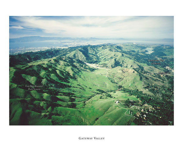
Decades of quarry activities and trucking
have left the scenic Gateway Valley eroded and its creeks
choked with sedimentation.
The developers charged their professional team with a thorough
analysis of the site’s original attributes and the means
of restoring them. In addition, the team did exhaustive analysis
of all the ecological zones and potential wildlife habitat
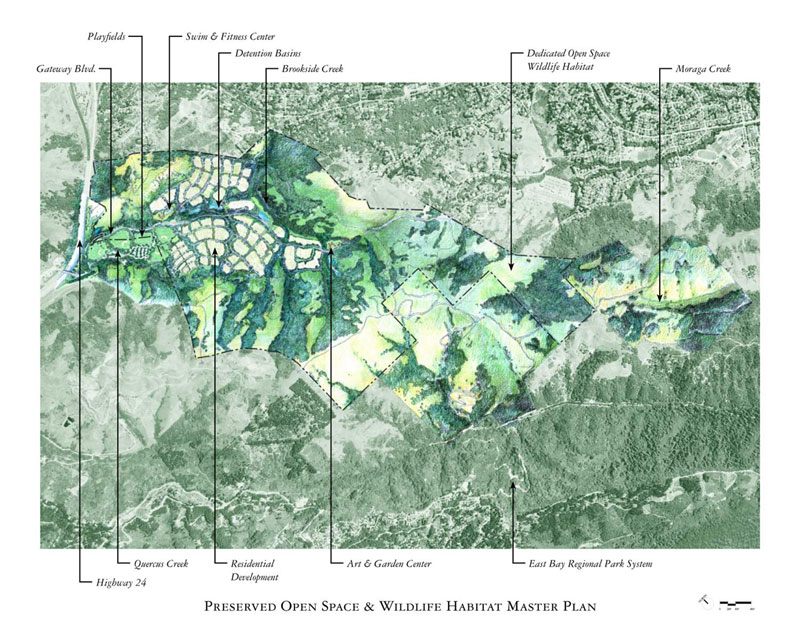
areas in concert with Federal and State agencies. The result
of this exercise had significant effect on the design of the
plan by setting aside enormous amounts of land to open space
and wildlife habitat. The development area was subsequently
clustered in the most environmentally distressed area. Drainage
patterns and wildlife movement corridors became the skeleton
for the new plan. The project team also had to respond to
Orinda residents’ concern over the future use of their
last undeveloped large private property. Citizen’s
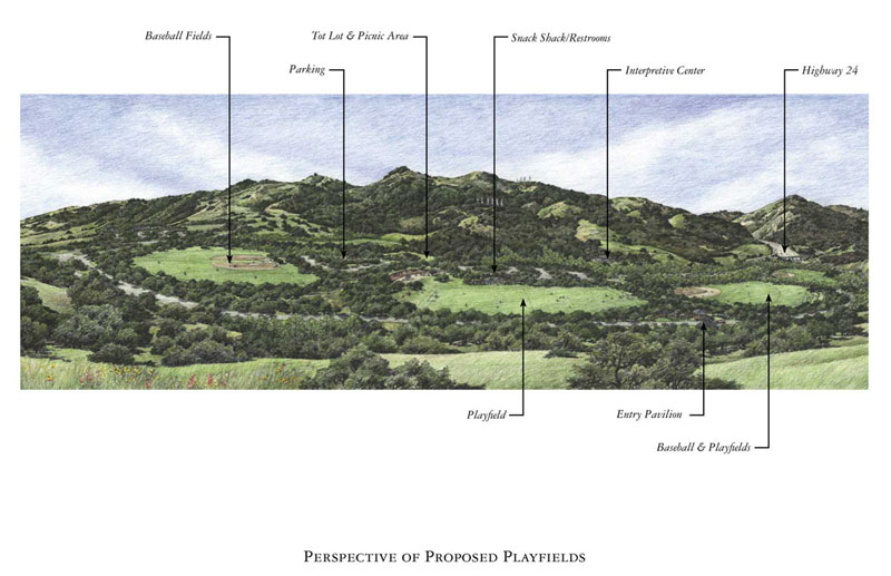
workshops quickly uncovered the dire need for playfields
to fulfill
their growing demand for active sports programs within a
geographic area severely challenged for level land. This
became one of
the most important elements to weave into an already tight
building envelope.
Planning for the valley associated with the environmentally
abused former quarry site has taken a long time; during the
past 16 years the property has changed hands three times,
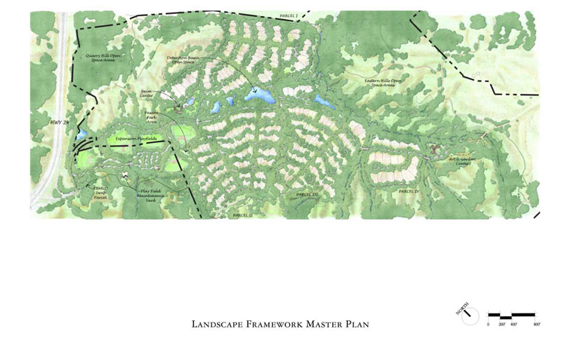
so the master planners served three consecutive clients. Forgoing
building a golf-oriented residential neighborhood, the new
owners will develop 245 hillside homes and a complex of recreational
facilities intended to serve the entire Orinda community.
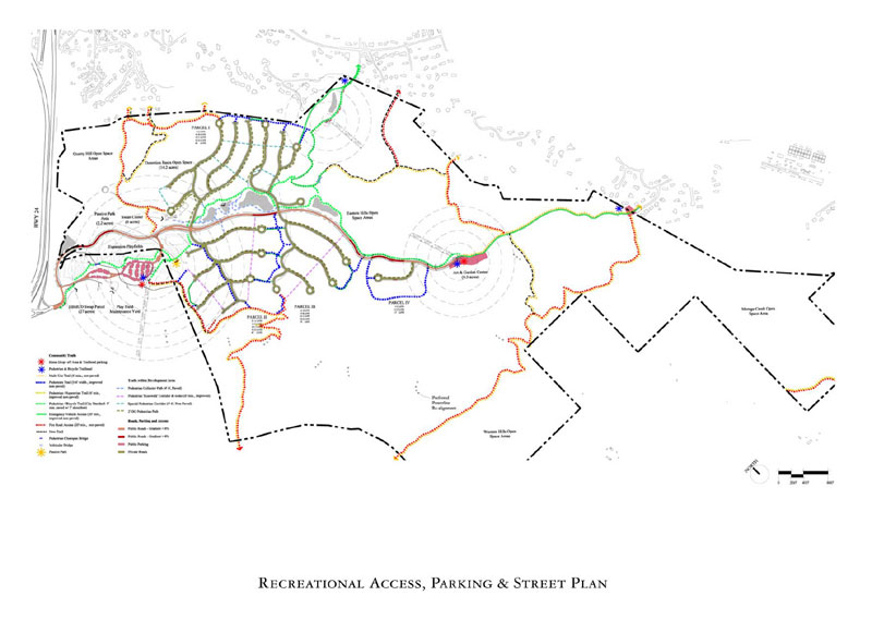
The final planning solution incorporated an integrated overlay
of wildlife, drainage and additional open space corridors
with trails and pedestrian movement systems reflective of
the patterns of the natural California rolling terrain of
ridges and valleys. Roads and home sites were subsequently
integrated into this organic design. Additional cultural elements
were subsequently added to enrich the plan including the use
of historic rosewalk pedestrian walkways to connect neighborhood
streets on the vertically challenged site.
Gateway Valley represents Orinda’s last available large
development site that is blessed with great natural amenities
and saddled with severe environmental constraints. The planning
process was characterized by painstaking environmental analysis
and extensive community input.
The application of local and regional characteristics is the
mainstay of the design approach. Local characteristics include
the semi-rural imagery of the Orinda neighborhood landscape
including curbless roads, use of drainage swales, roads that
are narrow in width, tree islands to break up the roadways,
and low scale building approach that blends with the natural
landscape. On a regional level, the plan reinforces the qualities
of the larger California landscape by making the natural drainage
swales and the higher ridge elements the main structure of
the plan. All other elements respond to these patterns.
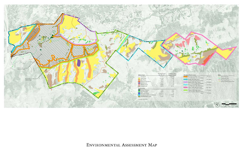
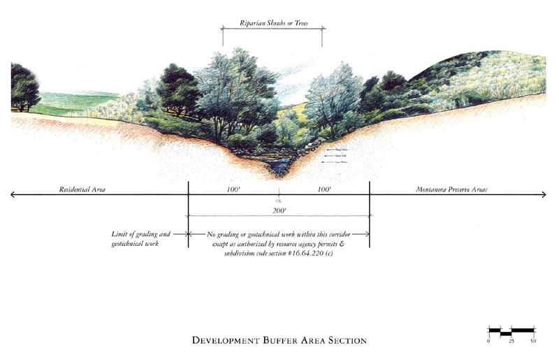
The project is enormously sensitive to the environment through
the use of over ninety percent of its land devoted to dedicated
and restored open space. The project can actually be understood
as a reclamation project. Proposed landscape approach is more
appropriately thought of as reforestation than as normal landscaping.
Plant types as well as natural planting patterns have all
been considered within the plan. The inclusion of drainage
swales along the roadways, as well as special water quality
control systems have all been incorporated into the project.
Because of the thoughtfulness and appropriateness of all the
environmental elements, the project has long range sustainability.
Pent-up demand for Orinda homes in a neighborhood setting,
within convenient access to jobs represents assurance that
the development will be built. Development Agreement signed
with the City of Orinda will assure that the development
will
be built in keeping with the plans. All environmental permitting
has been achieved due to the thoroughness of the team’s
efforts. The project is now moving into the tentative map
stage within construction to begin later this year.
The client will benefit from custom-sited, market-responsive
real estate products in a scenic neighborhood setting with
a dynamic open space and trail system that will be second
to none in the Bay area.
Orinda residents will welcome the opportunity for restoring
a devastated Gateway Valley and benefit from beautiful state-of-the-art-playfields
set into a natural and scenic setting.
Buyers will benefit from the design that
will assure both privacy and a sense of “connectedness” to
the surrounding natural open spaces and to a multitude
of community
amenities.
Other designers will appreciate the integrated system of
multi-purpose environmental corridors (rose walks and trails)
that provide convenient and beautiful means of scenic walks,
surface drainage and migration routes immediately adjacent
to their homes and connected to a regional open space system.
|
|
|
|
|
|
|
 |
 |
|
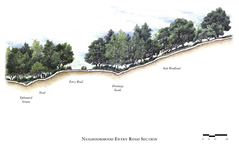
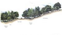
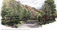
Narrow residential travel ways reinforce the rural character of the project while subtle grade variations and curved horizontal alignments assist in providing views of surrounding open space.
|
|
|
 |
|
|
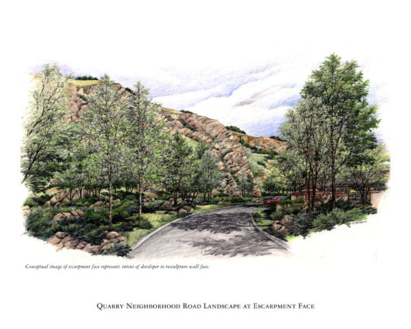
The vertical quarry escarpment face is a unique remnant landform that will be stabilized to create a more attractive visual transition between the quarry face and the surrounding landscape.
|
|
|
 |
|
|
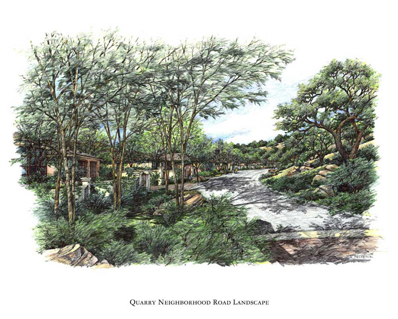
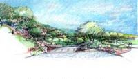
The residential hillside streets branch off the main entry road along the contours and have a more cultivated landscape image. They will be characterized by an unfolding sequence of driveways, entryways, courtyards, garden walls, architecture and visitor parking areas while the uphill side of the streets will retain a more open feeling of native open grasslands punctuated by occasional groupings of oaks. |
|
|
 |
|
|
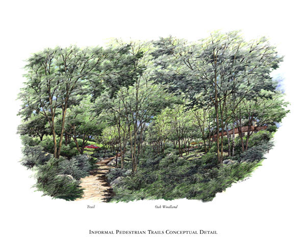
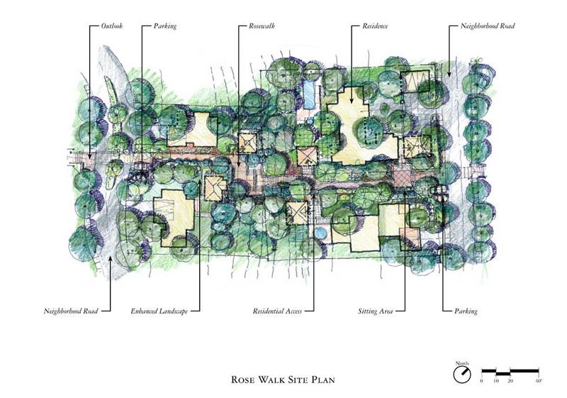
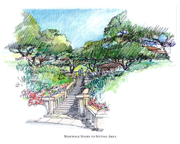
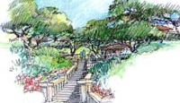
A network of paths, trails, and stairs provides connections thoughout historical neighborhoods within the adjacent Berkeley Hills. These quaint pedestrian walkways were the inspiration for the Gateway Rosewalks. These Rosewalks provide the pedestrian link between the adjoining trails from the East Bay Regional Park and the central core path system which links all of the community facilities within Gateway. |
|
|
 |
|
|
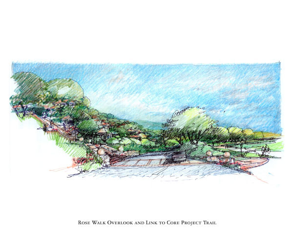
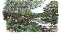
The Rosewalks are designed to assist pedestrians in navigating the hillside by providing stairs, rest stops, viewing platforms while also providing buffers between. The lower terminus of the neighborhood Rosewalks occurs at Gateway Boulevard where overlooks are situated for both views of Brookside Creek and future shuttle bus stops linking the community to Orinda and the regional Bay Area Transit stations. |
|
|
 |
|
|
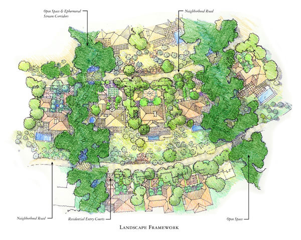
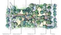
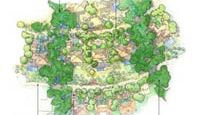
Rosewalks are a vital component of the overall landscape framework that integrates the development area with the surrounding 937 acres of preserved land and native habitat areas. These are more refined open space corridors which promote pedestrian movement throughout the project that parallel and reinforce the natural land forms of the surrounding hillsides. |
|
|
 |
|
|
Homes are organized as interrelated sets of indoor and outdoor rooms oriented to cross-valley views or will open onto sheltered outdoor rooms in the form of decks, patios, terraces to take advantage of Orindas Mediterranean climate. Hillside homes have been arranged in clusters of three to seven homes located between the landscape framework fingers that provide natural open space links to the community facilities and the adjoining preserve lands. |
|
|
|
|