The plans for the Calumet area are the boldest effort to
reverse decades of disinvestment, pollution and population
loss in an area dominated by steel mills and landfills. The
City’s goal for Calumet is to create a sustainable landscape,
where industry and open space are intermingled, interconnected
and to the greatest extent possible, co-existing harmoniously
by:
- Improving the quality of life in the Calumet area
and the surrounding communities
- Retaining and enhancing existing businesses and industries
within the Calumet area
- Attracting new industrial and business development,
and creating new job opportunities
- Protecting and enhancing wetland and natural areas
within the Calumet area, and improving habitat for nesting
and migratory birds and rare and endangered species
- Employing best management practices for sustainable
development of new industrial sites.
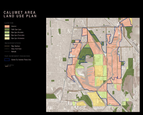
The Chicago Plan Commission adopted the Calumet Area Land
Use Plan in 2002. While the Land Use Plan was being completed,
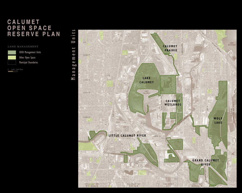
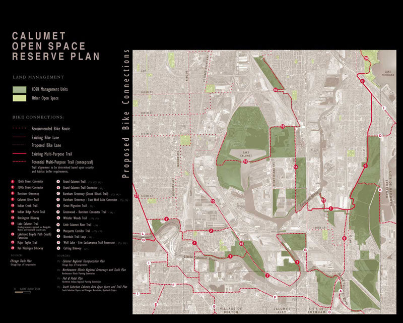
work began on the Calumet Open Space Reserve Plan, a document
detailing the 4,000 acres of natural areas and wetlands. Over
200 species of birds are known to migrate through or nest
in the Calumet area every year. Aquatic life is also surprisingly
abundant, especially considering that many of the bodies of
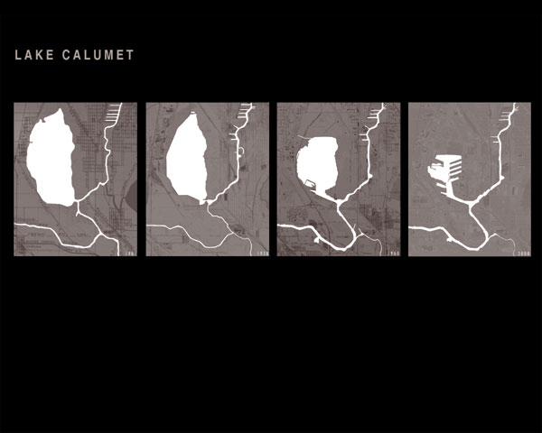
water are degraded, dredged or filled. Lake Calumet itself,
for example, has over 20 species of fish. The Reserve Plan
provides a vision for natural area preservation, rehabilitation,
recreation, and trail connections, and is a blueprint for
local government action.
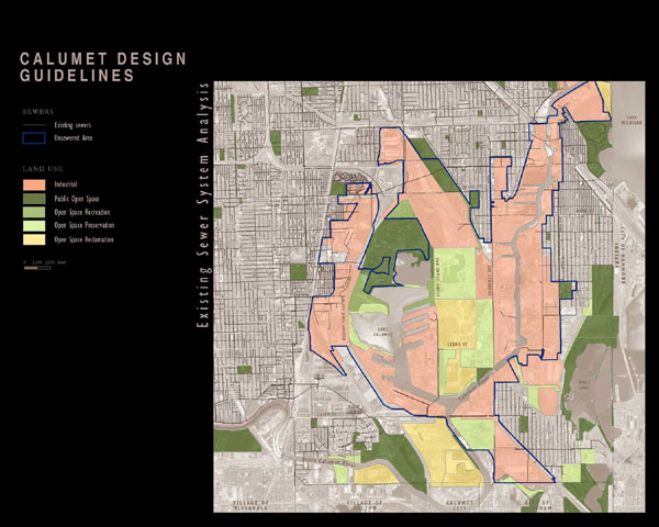
Concurrent with the Reserve Plan, the
City of Chicago developed the Calumet Design Guidelines,
which were adopted in March
of 2004. The Guidelines address the private property in the
area that is to be redeveloped for industry. The goal of
the
Guidelines is to articulate, describe and illustrate the
City of Chicago’s requirements for sustainable site
design in the Calumet area. The document provides background
information
on soils, hydrology and ecology and provides guidance on
the practical implementation of the Guidelines. The Guidelines
are directed at those charged with creating and implementing
a site design either for a new enterprise or for the expansion
of an existing business.
The basic tenets of the Land Use Plan, and the land use designations,
date back to 1985 when local residents and activists developed
plans to preserve natural areas and create recreational opportunities
in Calumet. But during that time the City of Chicago was exploring
filling in more of Lake Calumet for industry and construction
of a third airport as a way to ameliorate environmental problems.
Neither of those plans were realized
and by 1994 DPD began working with the Chicago Park District
(CPD) and the Forest
Preserve District of Cook County (FPDCC) on an open space
plan for Chicago. The result was the CitySpace Plan which
provided broad recommendations for increasing all types
of
open space in the city. It was in the CitySpace Plan that
the City’s vision of a sustainable Calumet area was
first introduced. That plan recommended pursuing “a
comprehensive preservation and industrial development strategy
for the Lake Calumet district.” By 1999, DPD was ready
to create such a plan for Calumet. The first step was to
collect
past plans and maps, which up until then had resided in the
files and minds of many different organizations and individuals.
Mapping the area proved to be the biggest challenge. Existing
maps of the far southeast side still showed ideas from a
1949
land use plan. Streets that had been platted but never built
appeared on City street maps. Following the development of
accurate maps, focus groups were conducted with industry,
community and environmental groups to solicit their opinions
on proposed land uses in order to identify where constituencies
and special interests both agreed and disagreed.
To develop the Calumet Open Space Reserve Plan a team of
landscape architects, planners, a writer and a landscape photographer
visited the sites. Planning staff collected information on
and mapped property ownership. The Department of Environment
(DOE) provided information, when available, on environmental
conditions. The Reserve Plan was created to provide information
and maps of each site, proposed ownership of unprotected sites,
and a proposed trail map for the entire area.
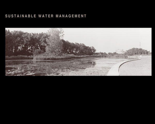
To develop the Calumet Design Guidelines a second professional
team was assembled that included landscape architects, planners,
a soil scientist, and a stormwater management specialist.
Initially it was thought that the main issue would be developing
a new plant palette. Site visits, document review and mapping
revealed that soil and hydrology issues were more challenging
physical constraints. Since large segments of the Calumet
area contained no sewers the Guidelines needed to direct developers
to utilize best management practices in areas with a high
seasonal water table.
Industry and nature both need large
expanses of land that are not encroached upon by residential
and commercial uses.
Factories don’t seem to bother the birds as much as
people do. Efforts to identify lands to be preserved for open
space and natural areas and lands to be designated for industrial
redevelopment had been attempted since the 1980’s when
U.S. Army Corps of Engineers initiated a Strategic Area Management
Plan (SAMP) for the Lake Calumet area. The SAMP indicated
that approximately 10% of the wetland sites were so sensitive
that they could never be filled, 10% could be filled with
a simple application, but the remaining 80% required site
by site review, leaving most of the wetlands in a land use
designation limbo.
The main purpose of the Land Use Plan was to resolve these
land use issues. For most of the land use designations a consensus
was reached among the participants in the partnership. In
one instance there is a large natural area abutting a railroad
yard. The railroad which owns the property intends to use
it for an intermodal yard, and the land was designated for
industrial uses, but the environmental partners did not agree
with that designation. Although the land use was not changed,
the text of the plan noted these areas where consensus was
not reached and all the partners supported the plan.
Land use plans for the redevelopment
of Chicago communities – residential, commercial, and industrial – have
generally treated open space as a homogeneous land use. In
the Land Use Plan four open space categories were identified
to direct future development. One is simply public open space
indicating land already in public ownership. Open space preservation
indicates sites to be preserved as habitat. Open space recreation
indicates sites that may be developed with public recreational
facilities. Open space reclamation refers to sites that have
been or are now used for waste management purposes. Those
sites will have an open space character and may continue to
be used for waste or water management. Later these open space
categories were used as the basis for the new open space zoning
designation developed through Chicago’s Zoning Reform
initiative.
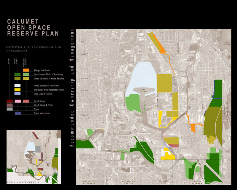
For the Calumet Open Space Reserve Plan
the critical decision is identifying which public agency
is best suited to own and
manage unprotected natural areas. The City’s role is
to acquire the lands and address environmental issues before
transferring the land to an appropriate land manager. There
are three open space managers that could expand their holdings
in Calumet. The Illinois Department of Natural Resources (IDNR)
owns all the land around Wolf Lake in Illinois. Given its
mandate to protect and manage the state’s natural resources,
the IDNR is the projected owner of lands in the reserve that
are known to provide habitat for threatened and endangered
species. The Forest Preserve District of Cook County (FPDCC)
currently is the largest open space manager in the reserve
with 865 acres in three forest preserves. The FPDCC’s
mission is the preservation and rehabilitation of the regional
landscape, and it could become the manager of the undeveloped
west shore of Lake Calumet, the most significant regional
landscape in the area. The CPD is the primary manager of
recreational
lands, facilities and programs in Chicago, and CPD will play
an important role in the reserve by managing the lands that
people will use most often.
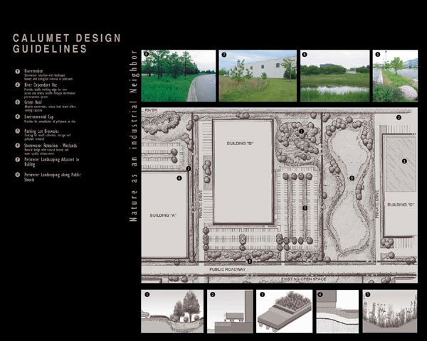
For industrial uses, the tracts of land in the Calumet area
differ from one another: Sizes and soil types vary; topography
changes from site to site; some locations have contamination
problems while others do not. It is expected that some solutions
suggested in the Calumet Design Guidelines will work for one
site but not for another. Those who are expanding present
facilities will have different challenges from those building
on vacant land. The practices described in the Guidelines
are intended to provide a menu of options for the developers.
The Calumet plans began when DPD and the non-profit organizations,
Openlands Project and the Southeast Chicago Development Commission
jointly submitted a grant to the U.S. EPA under its Sustainable
Development Challenge Grant program. The role of the non-profits
included outreach to and representation of the local environmental
and community groups. The planning partnership later included
DOE and Calumet Area Industrial Commission, a non-profit organization
representing area businesses. The Illinois International Port
District and Metropolitan Water Reclamation District of Greater
Chicago own large tracts in the area and DPD worked with both
agencies to get their concurrence on the land use designations.
For the Calumet Area Land Use Plan and the Calumet Open Space
Reserve Plan the primary design functions involved mapping
and photography. The Calumet area represents about 10% of
the land in Chicago - 20 square miles. Proposed land uses
for this area had to be conveyed to planners, legislators
and the general public. The area also had a reputation as
a dumping ground and a land of abandoned steel mills. Few
outside the area were aware of the existing natural areas
or of the beauty represented by the juxtaposition of the industrial
and natural landscape.
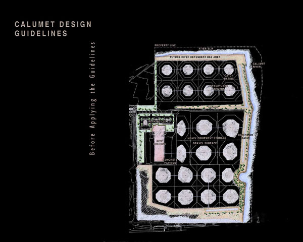
For the Calumet Design Guidelines section drawings were used
to illustrate the different site design options. Several boards
were developed to convey the guideline concepts to legislators,
developers and the general public.
The Calumet Tax Increment Financing District (TIF), the largest
in Chicago, was enacted in 2001. The TIF provides funds for
capital projects, including brownfield remediation and stormwater
management techniques for new developments. One year later
the Calumet Area Land Use Plan was adopted and since then:
- Approximately 1,000 new employees began work at
the Ford Manufacturing Campus, developed on a brownfield as
an expansion of the existing Ford plant.
- With the assistance of the Mayor’s Office of
Workforce Development, over 10,000 Chicago residents
were screened on a citywide basis to fill these new positions.
- In 2004 the Chicago Plan Commission approved the
Lake Calumet Planned Manufacturing District to prevent incompatible
land use encroachment within the Calumet industrial corridor.
- Government has spent over $200 million on road construction
and upgrades.
- The City and State codified their working relationship
in an intergovernmental agreement.
- The City and FPDCC are finalizing a similar agreement.
- The City has acquired over 300 acres of wetlands
and natural areas of statewide significance through donations,
tax sales, and acquisitions using state and federal grants.
- The Port District, the owner of Lake Calumet’s
west shore, has agreed to dedicate that land for preservation.
- In 2002 DOE published the Calumet Area Ecological
Management Strategy to provide a unified strategy for land
managers for rehabilitating the natural areas.
- More than 2,200 species were identified during the
2002 Calumet Biodiversity Blitz, a 24-hour inventory of Calumet
area species that involved over 100 scientists and scores
of volunteers.
- On April 22, 2004 DOE announced the winner of the
international design competition for the Ford Calumet
Environmental Center, which will “serve as a teaching tool between
nature and industry and between architecture and the environment.” DOE
has secured $6.6 million of private and public funds for
the center.
In 2000, Mayor Daley and then-Governor Ryan appointed an
advisory committee of local government, business and conservation
group representatives to advise on sustainable development
and industrial retention, natural area conservation, and environmental
cleanup projects. Fifty representatives were appointed to
the committee, which continues to meet several times a year.
City, county and state departments continue to use the plans
as a guide.
|