In the late 1950s, untreated wastewater flowed into the
Seattle area’s Lake Washington and Puget Sound, contaminating
the water and making the beaches unusable. To address this
problem, citizens voted to build a regional wastewater treatment
system which, by the late 1960s, resulted in dramatic improvements
to regional water quality. By the 1990s, the regional system
was reaching its design capacity. In response, the local
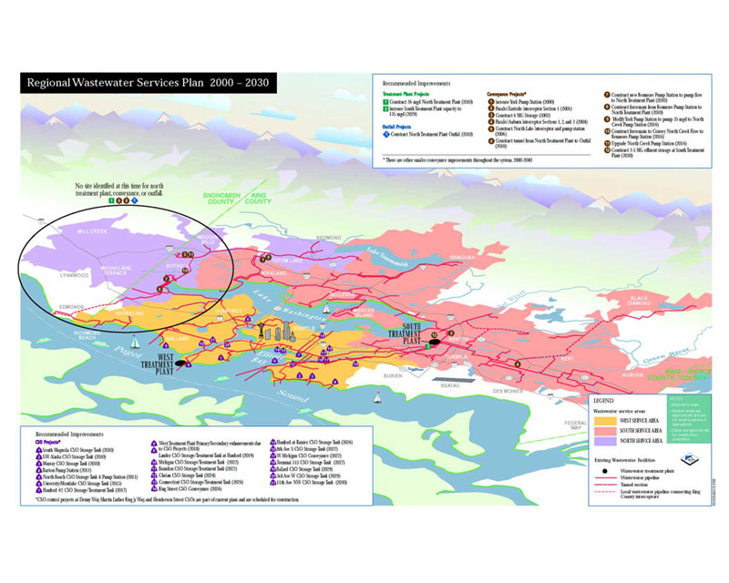
county initiated a long-range planning effort, termed the Regional
Wastewater Services Plan (RWSP), to meet the demands of continued
population growth and to protect the environment for the next
several decades. The RWSP was adopted by the County Council
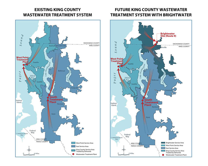
in December 1999. The largest single component of the RWSP
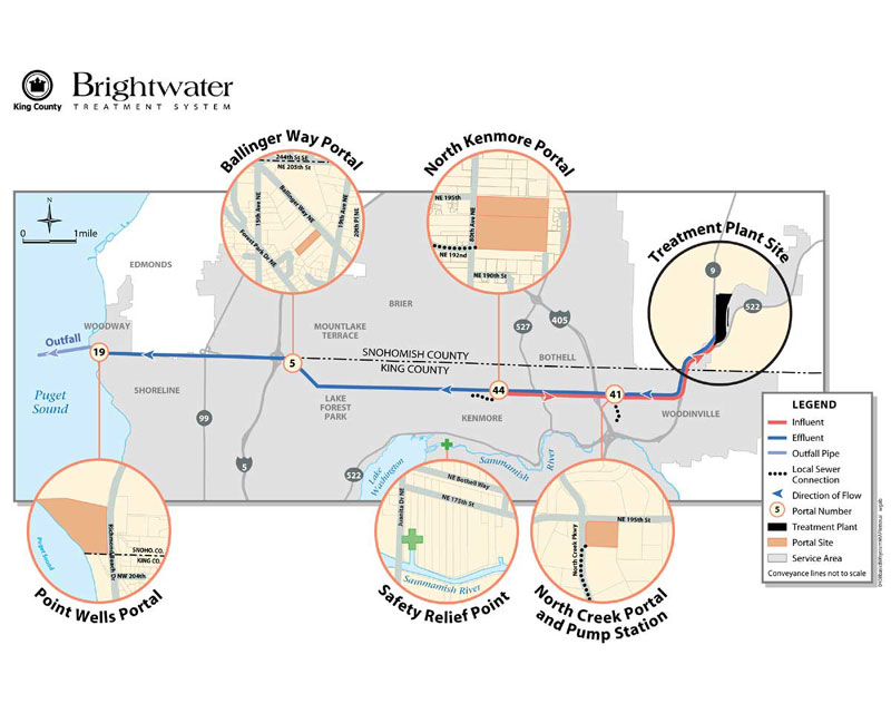
was a proposal to locate and construct a third regional treatment
plant and its associated conveyance tunnels and outfall, collectively
termed Brightwater.
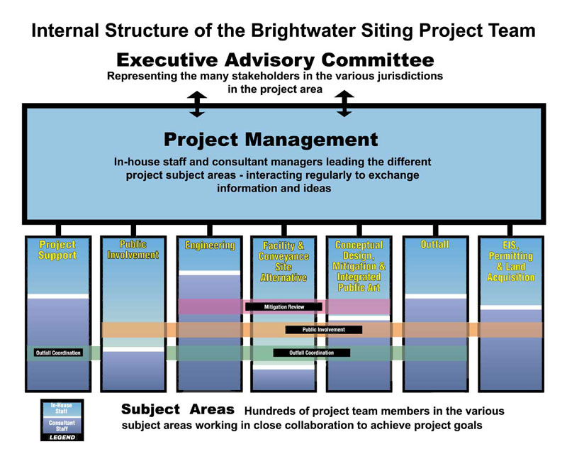
The Brightwater Siting Project was the first phase in the
site selection, design and construction of the wastewater
treatment facility, conveyance system and marine outfall.
The geographic scope of the project study area covered 200
square miles and encompassed 11 municipalities in two counties.
The complexity of technical, social, environmental and financial
information analyzed in the various jurisdictions within the
study area was extraordinary. Additionally, since many people
have considerable fear about how such facilities could affect
property values, groundwater and air quality, it challenged
the project team to develop a process that was clear, inclusive,
comprehensive and rational.
It was necessary to choose locations
for each element of the system that were technically and
economically feasible,
which would also benefit the natural environment and surrounding
communities. To meet those goals, the project’s biologists
and engineers collected and evaluated data on a wide range
of topics including the geologic profile, hydrology, and
ecological
and biological resources on land and in the marine outfall
zone. In addition, planners, landscape architects, architects
and artists studied a wide range of social and cultural
information,
which would allow the project team to select a site that
would allow the facility to blend well with the context
and become
a community amenity. This study included current land use
patterns, population density, transportation networks,
social
and economic nodes, history, cultural identity, growth management
plans and the character of the surrounding landscape and
architectural
styles throughout the project area.
At the beginning, the county formed an Executive Advisory
Committee, which included representatives from two tribal
governments, eleven cities and towns, three utility districts,
and several environmental, labor, business, community and
economic development organizations. This committee provided
input on site selection criteria, reviewed decisions made
by the project team, and provided feedback on a variety of
issues throughout the process.
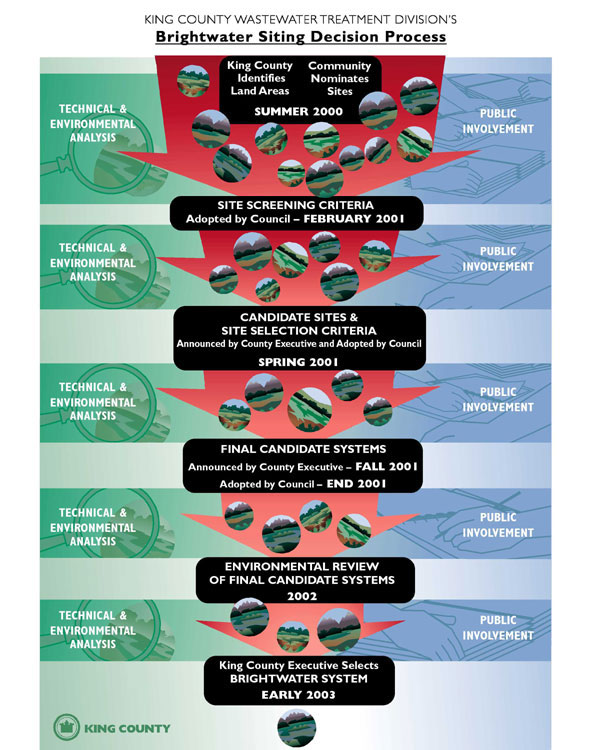
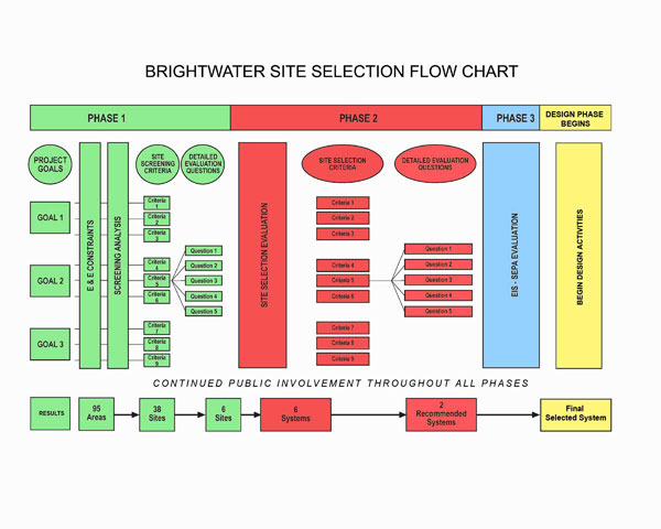
The strategy developed for the project was designed to support
unbiased decision-making at three increasingly detailed phases
of analysis. Site selection criteria were developed with input
from key project staff, the general public and the Executive
Advisory Committee. Each criteria item was formally approved
by the County Council. Key siting criteria ensured the selection
of a treatment facility, conveyance and outfall location that
would:
- support the Growth Management Act, which was designed
to balance social uses with environmental protection by maximizing
developable urban land while respecting natural systems.
- provide adequate area for proposed facilities, buffer,
and future upgrades.
- not displace an existing use that provides for law
enforcement or public safety training.
- protect municipal drinking water wells and potable
groundwater.
- fully comply with all regulations and protect public
health.
- be feasible within the County’s financial
security and bonding capacity.
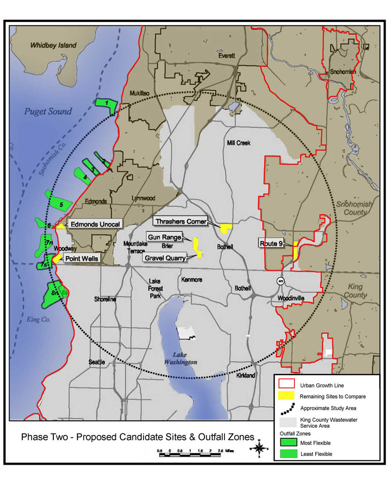
To administer the policy siting criteria at each phase, detailed-evaluation
questions (DEQs) were developed and applied to each site.
As the process advanced, and better candidate sites emerged,
greater detail and complexity were built into the DEQs. That
way, the initial wide-ranging search area could be evaluated
with a relatively coarse filter, dropping from consideration
those sites that failed to meet fundamental requirements.
This strategy allowed the project team to steadily refine
the analysis until one final system was selected.
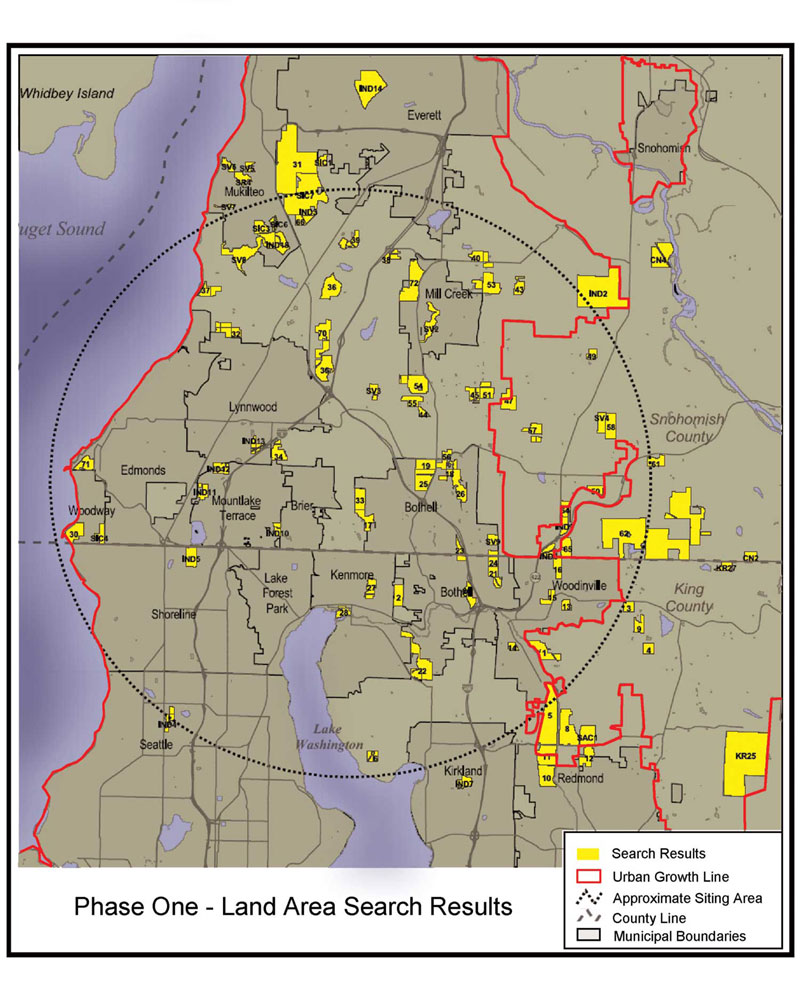
The project team began with a list of 100 sites, which were
found through a geographic information systems (GIS) study,
commercial/industrial land search, and community nominations
process. At each phase of analysis, the list of sites was
reduced by applying the DEQs. While computer software helped
organize and process the information, the evaluation was carried
out in interactive workshops, allowing engineers, environmental
planners, landscape architects, and other key team players
to actively discuss the issues from multiple points of view.
This allowed the project team to integrate the various perspectives
into one unified process.
The public participation program played a central role in
the planning effort. Throughout every phase, the project team
sought feedback from citizens. Members of the public had opportunities
to nominate sites for consideration, help develop site selection
criteria, comment on sites, conveyance and outfall locations,
suggest mitigation measures, help develop guidelines for facility
designers, and comment on the EIS. During the siting process,
there were approximately 400 meetings and briefings and 50
large public workshops. The team also interviewed community,
business and organization leaders; distributed newsletters,
booklets and pamphlets; distributed several videos on different
formats; and constantly updated the project website. Between
January 1, 2000 and December 31, 2003, the project staff documented
approximately 2600 calls, letters, e-mails, faxes, and one-on-one
interactions between project team members and the public.
Such opportunities allowed in-depth public exploration of
the issues to an extent that far exceeds most public participation
programs.
At the end of four years of the above activities, the project
team was able to identify one system that was most suitable
in engineering, community and environmental areas, for the
following reasons:
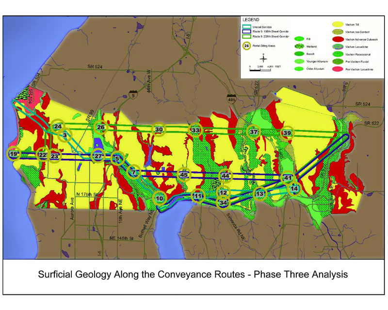
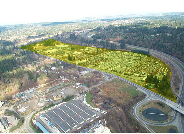
Engineering: The treatment
site itself, dubbed Route 9, will be easier to build on
than other sites
because it is larger and flatter. In addition, groundwater
levels won’t cause problems during construction,
and soils on the site are not prone to liquefaction. For
those
reasons, it does not require special engineering solutions
such as terracing or pilings. Because of its size, there
is
more space on-site for construction staging, materials storage
and worker parking.
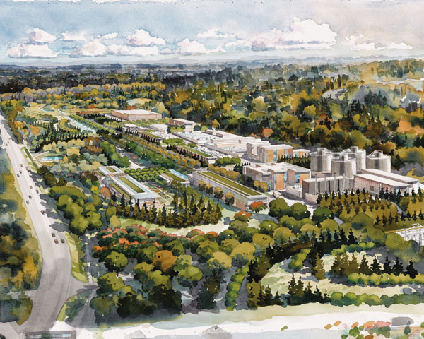
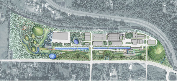
Community: Because of the large site, the
main facility structures can be set back several hundred feet
from the closest houses. This extra space will provide a buffer
for construction noise and dust. Once construction is complete,
the facility will offer a large step forward in community
renewal. A landscaped buffer will screen the facility from
view, replacing auto yards and restoring the rural and natural
qualities of the surrounding area that much of the community
has been sad to see disappear over the years. In addition,
the community/education building and outdoor plaza spaces
(proposed by the public as elements of mitigation) will be
open for a variety of programmed community activities. Because
of its large size, a significant area of the overall site
will be open for public use.
Environment: While most other sites would
have imposed damage on local ecological systems, the Route
9 site provided opportunities to restore and enhance them.
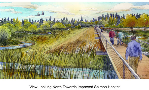
Little Bear Creek runs adjacent to the site. It is a salmon-bearing
stream that has been steadily losing the battle against the
effects of urbanization. Additionally, there is a small wetland
on-site. Eleven streams and water courses flow across the
site, feeding into Little Bear Creek. One of the biggest problems
associated with the creek is the damaged hydrological regime
caused by the large amount of impervious surfaces on the existing
site. The selection of this site provided the opportunity
to protect and enhance those vital habitat features. It allowed
for over 60 acres of reforestation, and an even larger area
of new pervious surfaces. Additionally, all on-site stormwater
will be conveyed into the wetlands, after being treated naturally.
This increased supply of water will allow the landscape architects
to increase the size of the existing wetland, allowing for
more habitat for salmon and other native wildlife. From the
wetland, the water can be released at a steady rate into Little
Bear Creek, providing a fresh supply of clean water into the
creek year-round, reversing the long term process of ecological
degradation caused by current industrial uses.
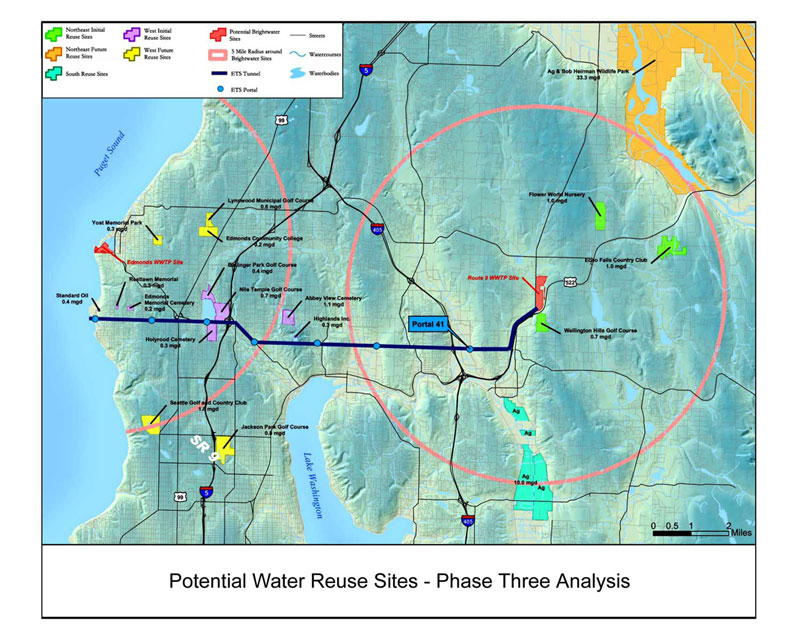
In addition, the project team analyzed and planned for opportunities
to distribute reclaimed water from the candidate sites. Reclaimed
water is defined as sewage that has been treated to the extent
at which it can be used for irrigation or industrial use.
Its production at Brightwater would significantly reduce our
reliance on fresh water from local sources. Early in the process
the project team took an inventory of large-scale water consumers,
such as cemeteries, golf courses, wildlife parks and other
such lands. The Route 9 site scored high in this category
because of its rural location and longer conveyance corridor
that would provide for a much larger geographic area possible
for the distribution of reclaimed water.
The Brightwater Siting Project was an important piece of
the Regional Wastewater Services Plan. The comprehensive,
participatory process laid the foundation for its successful
implementation. The project is currently in the design phase,
and construction is scheduled to begin in 2006. When Brightwater
opens in 2010, this third treatment plant in the regional
wastewater treatment system will be a significant investment
in our future, protecting public health, the environment,
and providing the infrastructure needed to encourage economic
investment as our region continues to grow. In addition, the
process itself contributed to all communities involved in
the project area. It sparked interaction among elected officials,
project staff and the public at-large, fostering the healthy
civic debate that is an elemental component of the democratic
society in which we live.
|